Precision agriculture substitutes information and knowledge for physical inputs of fertilizers, pesticides, and other treatments. It is a philosophy and system of crop management that has become an important development in modern agriculture. Critical economic, scientific and environmental factors justify these methods which are designed to maximize crop productivity, profitability, and environmental sustainability.
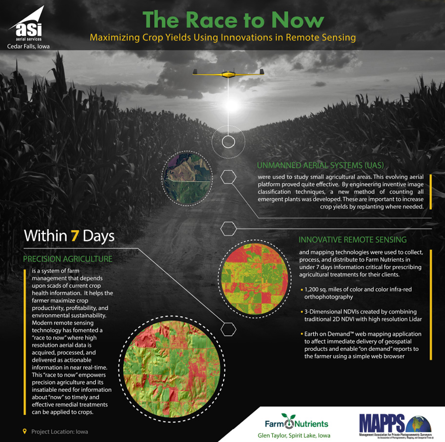
Modern remote sensing technology comprised of everything from sophisticated multispectral cameras and Lidar to Unmanned Aerial Systems (UAS) and instant communications have conspired to foment a “race to now” where high resolution aerial data is acquired, processed, and delivered as actionable information as close to immediately after acquisition as possible. This “race to now” in remote sensing wonderfully empowers precision agriculture because of its insatiable information for current crop information needed for devising timely and effective remedial treatments.
Farm Nutrients (Rembrant, IA) asked Aerial Services’ to help them to build a new web-based precision agriculture service for use with other farm managers, crop scouts, and farmers. The remote sensing solution needed to meet the following criteria:
- Aerial acquisition and delivery to end users of multispectral (4-band) high resolution (12” GSD) ortho imagery of 1,200 square miles of agricultural area.
- Produce and deliver Normalized Difference Vegetation Indices for the entire area.
- Both of these specifications must be completed within 7 days after acquisition.
To achieve these ambitious imperatives Aerial Services used an innovative combination of existing technologies (orthophoto automation, NDVI production, and webmapping) in novel ways.
Farm Nutrients’ vision is to collect timely crop health information over vast areas (1,200 sq. miles) throughout Iowa, Minnesota, and Missouri. Prior to asking Aerial Services for help, they had spent a number of years collaborating with an Unmanned Aerial Vehicle firm to build and deploy drones to collect this information. This multi-year effort had produced little success. Aerial Services helped them understand that drones were not the solution to scale economically to the large geographic areas for which they needed current, high resolution (12” GSD) aerial photography. They needed manned aircraft and metric multispectral cameras to achieve their vision – products and services within Aerial Services wheelhouse for many decades.
The challenges to this project were not to photograph and create high resolution multispectral orthophotography over a large geographic area. This is routine activity at Aerial Services. The real challenge was to produce and deliver this quantity of information in under 7 days.
Agricultural information of growing crops is very valuable when current. Because the crops are rapidly growing and weather patterns are in flux, remote sensing information must be distilled then acted upon by the farmer in near real time. Orthophotography and detailed crop health assessments (NDVI) from Aerial Services had to get into the farmers hands within 7 days or its utility to affect yield would be diminished. Aerial Services responded to this “rush to now” requirement by enabling five important innovations.
First, we had previously developed automated methods to process vast quantities of aerial photography into quality orthophotography. These systems however, were further optimized so we could complete in a matter of hours what normally would have taken us weeks to produce. Aerial Services has used the Leica ADS-80 digital camera system for years and has developed a number of sophisticated automated routines that facilitate the rapid ingest of raw aerial photography and production of orthophotography. This project required further tuning of these automated routines and a different “focus” of personnel to complete in just 5 days what would normally have taken eight weeks.
Second, Aerial Services developed new automated techniques to rapidly create NDVIs over this large area (1,200 sq. miles) of high resolution imagery. The NDVIs from this high resolution imagery were remarkable in detail … details simply not visible from satellite or public imagery. As it turns out, these details were important indicators that helped Farm Nutrient crop scientists identify faulty application equipment and other human practices that impact yield. For example, individual malfunctioning planter heads or compaction issues caused by equipment could be identified in the NDVIs. In addition, areas of poor or sub-par crop health were readily visible. In June record flooding occurred over large portions of this area. We were able to quickly identify and automatically map all flooded areas with destroyed crops using these NDVIs.
An additional advantage of using good geospatial mapping practices that was important to Farm Nutrients was that all of these crop areas (good, medium, or bad health) were immediately mapable and quantifiable in their GIS application. Crop areas needing remediation could be uploaded into the tractor’s GPS and used to apply crop treatments precisely where needed. Aerial Services used ESRI Arcmap as the core GIS system to generate the raw NDVIs. However, new, sophisticated Arcmap “models” were created that automated the over 2-dozen steps required to create the NDVIs over the 1,200 sq. mile area. This automation required considerable ingenuity and inventiveness from our geospatial engineers.
Third, our core geospatial inventiveness was leveraged to transform the standard NDVI that has been in use for decades and to adorn it with a 3D perspective. This was achieved by draping the high resolution (GSD: 12”) NDVI over a detailed Lidar surface model. The resultant 3D NDVI could then be interpreted within the 3D spatial context in which the farmer experiences his crops each day. This dramatically improved the crop scientists’ and farmers’ ability to understand the NDVI. Not only could they more easily recognize “where” they were looking because the NDVI of their field looked much more familiar in 3D, but the crop areas that showed sub-par health in the traditional 2D NDVI that were difficult to understand suddenly now made much more sense. For example, when viewing areas of poor crop health in the 3D NDVI it became immediately obvious much of that was due to being located in areas prone to poor drainage (up on a very dry hilltop or down in a very wet drainage).
Fourth, Aerial Services deployed our Earth On Demand™ web services to deliver all of this rich, current crop health information to the end user immediately after orthophoto production was completed. This remains a critical component of this successful project because of the high value of “current” crop information and the rate at which this value degrades over time. Delivery of this volume of information using traditional methods of hard drive shipments would have required many more days of shipping and data management before the end user could use it to solve problems and inform management decisions.
Aerial Services developed new, automated routines to rapidly ingest high resolution 4-band orthophotography and NDVI rasters, then “tile” them for distribution in OGC-compliant web services. This automated process included tiling all of the imagery, moving all the tiles to our cloud-based web servers, and initializing the web services so the client could have immediate access.
[/spb_boxed_content] [spb_boxed_content type=”coloured” box_link_target=”_self” padding_vertical=”0″ padding_horizontal=”0″ width=”2/3″ el_position=”first”]
Last, Aerial Services designed a web application on top of these web mapping services. The application mashed 10’s of thousands of vector outlines of all farm/field boundaries with the high resolution 4-band orthophotography, NDVIs, and Lidar elevation data in the webmapping services. This application proved to be extremely intuitive and easy to use because it was browser-based and all end users could interact with the service on any device using only a web browser.
This innovative combination of important technologies enabled the end user to quickly find critical, time-sensitive crop health information about any specific farm / field. Further, they could optionally purchase an automated crop health report (PDF) generated from the most current plant health information for a particular (or group of) farm / fields
Another important component of this project was performing remote sensing over individual farms or research plots using Unmanned Aerial Vehicles (UAVs). During this period and the three prior years regulations forbid the commercial operation of UAVs. Only “public entities” like Universities were allowed to operate drones. Therefore, Aerial Services established a partnership with the University of Northern Iowa to do R&D with remote sensing drones and established some of the earliest “certificates of authorization” (COAs) in the country on behalf of the University so this R&D could be performed in central Iowa.
This experience was important to Farm Nutrients. They needed a faster, better method of counting plant emergence in corn fields. Traditionally, plant emergence is estimated using very small statistical sampling plots. This technique is sufficient, though costly requiring considerable manual labor. However, estimates of plant counts using a very small field sampling can vary dramatically due to soil, moisture, and planting factors extant within a single field.
Nevertheless, plant densities immediately after emergence are a critical measure of ultimate crop yield. If low crop counts within a farm/field can be identified, there is a very narrow window in time to replant these areas and dramatically improve yield. For these reasons, obtaining an accurate plant count in a farmer’s fields can have tremendous effect on the farmer’s ultimate return on investment. Farm Nutrients asked if we could help them use remote sensing techniques to not only better estimate crop counts in a field but count every crop in a field so holes of low counts could be identified and replanted.
This was a perfect application for drones and because of our research with the University we were able to test a number of automated “plant counting” models using ArcMap and high resolution, multispectral imagery acquired from drones. Special red-edge 3-band (R, G, IR) cameras were flown using drones to acquire high resolution imagery of emergent plants. The rectified color infrared aerial photography was used with newly innovated image classification routines to identify, then count, emergent plants. These new plant counting techniques proved to be fast, counted every plant in a field, and produced maps showing crop densities (Figure 4). This geospatial information can then be loaded into GPS-enabled planting equipment and effective treatments applied to remediate areas with low plant densities (Figure 4).
These techniques continue to be used today to deliver cutting edge crop management solutions to Farm Nutrients clients throughout the Midwest. They will, in turn, give the farmers new tools with which to target, and ultimately reduce, the application of pesticides and fertilizers across broad areas of land and maximize environmental sustainability, crop yield and return on investment. Earth On Demand™ continues to be the back office technology that empowers the distribution of critical, time-sensitive crop health information acquired using both manned and unmanned systems over very large areas and individual fields. High resolution 3D NDVIs continue to impress their clients with crop health information simply unavailable from anyone else. UAVs have enabled Farm Nutrients to more intensively manage high value areas in more economical ways than previously possible and at less risk to property and lives.
Aerial Services completed delivery of all geospatial data in just six days. This exceeded the client’s expectations and demonstrated that with commitment, innovation, and geospatial expertise important new value can be delivered to the precision agriculture community in their “race to now”. As historical crop assessment information accumulates in this application every time, the value of this historical crop data grows and will produce much additional value to the stakeholders.
