Radiometry is the science of measuring light in any portion of the electromagnetic spectrum. In practice, the term is usually limited to the measurement of infrared, visible and ultraviolet light using optical instruments. Irradiance is the intensity of light and is measured in watts per square meter.
Radiometric Techniques are a set of methods used in remote sensing and imaging to extract useful information from the electromagnetic radiation emitted or reflected by objects on Earth’s surface. They can be useful in a variety of contexts where remote sensing or imaging is needed to analyze or monitor objects on Earth’s surface.
For example, radiometric techniques can be used in environmental monitoring to monitor changes in land cover, vegetation, and water quality. In agriculture, these techniques can be used to analyze crop health, estimate yield, and monitor irrigation.
In geology, radiometric techniques can be used to identify and analyze mineral deposits, geologic structures, and other features of the Earth’s surface. Urban planning can also benefit from these techniques as they can be used to analyze land use, urban growth patterns, and changes in urban infrastructure.
Additionally, radiometric techniques can be used for intelligence gathering, surveillance, disaster response, environmental monitoring, agriculture, geology, urban planning, and search and rescue operations.
Common techniques include:
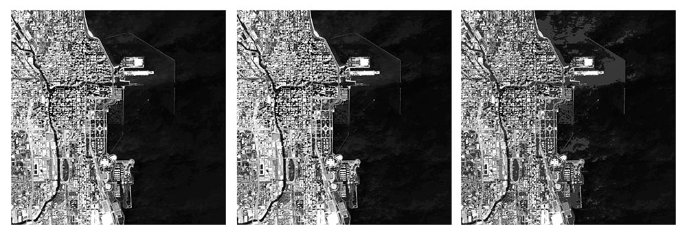
- Spectral analysis: This involves analyzing the properties of electromagnetic radiation at different wavelengths to identify the composition and characteristics of objects on the Earth’s surface.
- Thermal imaging: This technique involves using infrared radiation to detect and measure heat emitted by objects. It is commonly used in applications such as building inspections, industrial inspections, and search and rescue operations.
- Radiometric calibration: This technique involves measuring and adjusting the output of remote sensing instruments to ensure accurate and consistent measurements.
- Atmospheric correction: This technique involves removing the effects of atmospheric interference from remote sensing data, which can improve the accuracy of measurements.
- Polarimetry: This involves analyzing the polarization properties of electromagnetic radiation to identify the physical properties of objects on the Earth’s surface.
- Multispectral imaging: This technique involves capturing images at multiple wavelengths to identify different features and characteristics of objects on the Earth’s surface.
These techniques are constantly evolving and improving with advances in technology, and they play a crucial role in our ability to monitor and understand our environment.
After taking the photos, they need to be examined for correctness and adjusted to emphasize or enhance the intended purpose, which can involve reviewing a large number of images, sometimes exceeding 1,000. Each image may require up to 100 edit points to be adjusted by hand, which can consume as much as thirty minutes. When done manually, the editing of each image can cause delays in product delivery that could last over a week or even longer. To address this issue, batch processing is implemented to guarantee speedy, precise, and high-quality delivery of images.
 Batch processing is a way to perform repetitive tasks on multiple images at once in Photoshop. Instead of editing each image manually, which could take a lot of time, you can automate the process with batch processing.
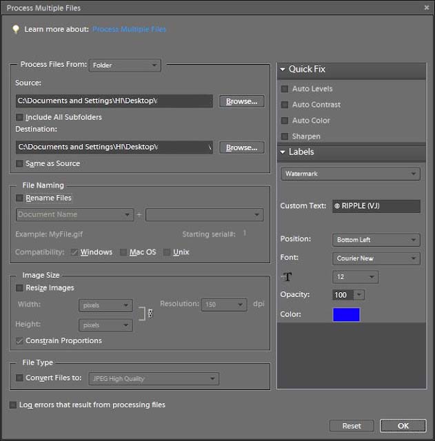
First, you need to create a set of instructions called “actions” that tell Photoshop what edits to make to the images. You can record these actions by performing the edits manually on a single image and then saving the actions.
Next, you select the group of images you want to edit and run the batch process using the actions you’ve created. Photoshop will then apply the same edits to each image in the group automatically, without the need for you to do it manually.
This can save a lot of time and effort when dealing with large quantities of images that require the same edits. It’s a useful feature for photographers, graphic designers, and anyone who needs to edit a large number of images quickly and efficiently.
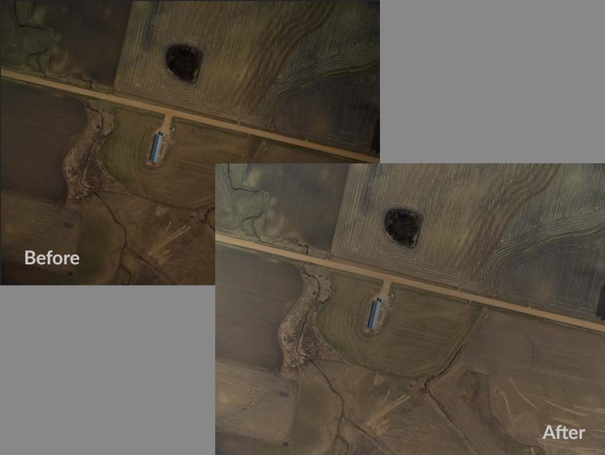 One example of batch processing with radiometric images processing is to adjust the color balance of a set of images to compensate for differences in lighting conditions. This can be done using the “Auto Color” or “Levels” adjustment tools in Photoshop, which can automatically adjust the levels of the red, green, and blue channels in your images to achieve a more balanced color profile. You can then apply this adjustment to multiple images at once using the batch processing feature in Photoshop.
Radiometric techniques and processing are crucial for remote sensing and imaging to extract information from electromagnetic radiation emitted or reflected by objects on Earth’s surface. These techniques enable us to monitor and understand the environment, analyze land use, vegetation, water quality, mineral deposits, and other surface features. Batch processing is an efficient way to handle a large number of images that require the same edits, saving time and effort. As technology advances, radiometric techniques will continue to improve, providing more accurate measurements and better environmental management. Using radiometric techniques in batch processing can streamline image editing workflows and achieve consistent results across multiple images.
