Aerial photogrammetry is a process of extracting information from aerial images captured by drones, aircraft, or satellites. It is an essential technique used in several fields like cartography, remote sensing, urban planning, and natural resource management. Automated Aerial Triangulation (AAT) is an important step in the photogrammetry process that involves the accurate measurement of ground coordinates of objects in aerial images. In this blog post, we will discuss the concept of Automated Aerial Triangulation, its importance, and how
What is Automated Aerial Triangulation?
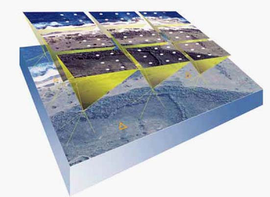
Aerial Triangulation (AT) is the process of determining the precise position of each aerial photograph in space by identifying the exact location and orientation of the camera at the time of exposure. Automated Aerial Triangulation (AAT) is a computerized process that automates this process by identifying the corresponding points in multiple overlapping images, calculating the camera’s position, and generating a Digital Elevation Model (DEM).
Why is Automated Aerial Triangulation important?
Automated Aerial Triangulation is an essential process in aerial photogrammetry as it helps to produce accurate and reliable data. Accurate data is crucial for several applications such as urban planning, land-use analysis, environmental monitoring, and disaster management. Moreover, manual aerial triangulation is a time-consuming process that requires skilled personnel, and errors can occur due to human bias or inconsistencies. Automating this process ensures faster processing, higher accuracy, and reduced cost.
With Urban Planning, automated aerial triangulation is used to create high-resolution maps of urban areas. These maps can be used to identify existing structures and infrastructure, as well as potential development sites and are paramount in assessing the impact of new developments on the surrounding environment.
Another application of this technology is in monitoring changes in land cover and land use, providing valuable insights into the impact of human activity on the environment. By using automated aerial triangulation to create high-resolution maps of specific areas over time, researchers and policymakers can monitor changes in vegetation cover, water resources, and other environmental factors.
How is Automated Aerial Triangulation performed?
The process of Automated Aerial Triangulation can be divided into three stages: Image Pre-processing, Aerial Triangulation, and Digital Elevation Model (DEM) generation.
Image Pre-processing:
The first stage involves image pre-processing, where the images are prepared for Aerial Triangulation. The pre-processing steps include:
- Orientation and Calibration: The images are corrected for distortion and the camera’s interior and exterior orientation parameters are determined.
- Image Matching: The overlapping images are matched to identify common features in multiple images. This process is performed using feature-based matching algorithms such as SIFT, SURF, or ORB.
- Bundle Block Adjustment: The camera positions and orientation are adjusted to ensure consistency across all the images.
Aerial Triangulation:
The second stage involves the actual process of Automated Aerial Triangulation. The steps involved are:
- Ground Control Point Identification: Ground Control Points (GCPs) are identified in the images. These are points with known coordinates on the ground
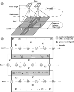 and they are used as reference points to determine the camera positions.
 - Tie Point Identification: Tie Points are the corresponding points in multiple images that are used to triangulate the camera positions. These points are identified automatically using the image matching algorithms.
- Aerial Triangulation: The camera positions and orientation are calculated by triangulating the GCPs and Tie Points. The triangulation is performed using mathematical algorithms such as Least Squares Adjustment or Bundle Adjustment.

Digital Elevation Model (DEM) Generation:
The final stage involves generating the Digital Elevation Model (DEM) from the Aerial Triangulation results. The DEM is a 3D representation of the terrain, and it is generated by interpolating the height values of the Tie Points. The height values are obtained by comparing the Tie Points’ image coordinates with their known ground coordinates.
Conclusion
Automated aerial triangulation is an essential process for a variety of industries and applications. It has proven to be a valuable process for infrastructure projects, allowing engineers and planners to create detailed 3D models of proposed development sites, assess their feasibility, identify potential challenges and hazards, and optimize their design. This helps to ensure that infrastructure projects are safe, efficient, and sustainable, and that they meet the needs of the communities they serve.
Overall, the benefits of automated aerial triangulation are clear. By providing accurate and detailed information about the natural world and built environment, it helps us to better understand our environment, manage our resources, and plan for a sustainable future. As technology continues to advance, it is likely that automated aerial triangulation will become even more essential, providing us with new and innovative ways to map, measure, and analyze the world around us.
