
Oblique Imagery for a Multitude of Applications
ASI’s Snyp’Air oblique imagery system offers high-resolution metric camera imagery coupled with geotagged 4K video and automated feature targeting capabilities, making it an excellent tool
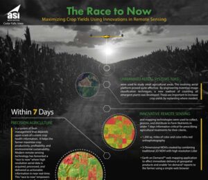
The Race to Now – Maximizing Crop Yields Using Innovations in Remote Sensing
Precision agriculture substitutes information and knowledge for physical inputs of fertilizers, pesticides, and other treatments. It is a philosophy and system of crop management that

Earth on Demand Web Services
Earth On Demand Web Services™ is a cloud based geospatial streaming solution that supports Open Geospatial Consortium (OGC) streaming services and is compatible with all

LiDAR Use | Wind Turbine Industry
Although most of LiDAR news we read today has to do with aerial LiDAR and mapping of the Earth’s surface, mobile LiDAR has been used

Glossary of Cyber Security Terms
Editor’s Note: the 3-part article on Personal Internet Security for Geospatial Professionals originally (2017) referenced this glossary. Adware What it means: Adware is an annoying form

ASI Wins MAPPS Excellence Award for Fourth Time
[spb_boxed_content type=”coloured” box_link_target=”_self” padding_vertical=”0″ padding_horizontal=”0″ width=”1/1″ el_position=”first last”] MAPPS kicked off the year in January by hosting their annual winter meetings, this year in beautiful

WebGL
You may have not heard of WebGL (Web Graphics Library) before but I bet you have used it. I remember first experiencing it back in

Implications of Drones on American Privacy and Freedom
Drones have grown up in the theater of war over the last 20 years being used primarily to “kill” and “spy”. As this technology is

Principles of Remote Sensing and Mapping Using Drones
As with any new technology while in the “wild west” stage of development, unfounded, erroneous assumptions are made by practitioners about the positional accuracy of