
How NOT to Procure Geospatial Solutions
As you prepare for a new year and a new budget, Aerial Services, Inc. (ASI) would like to share with our guide on how NOT

The Onslaught of AI and Implications for the Geospatial Professional
By the 2040s we will have the opportunity to apply the accumulated knowledge and skills of our civilization to computational platforms that are billions of

HEIGHTS 2022
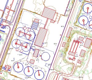
ASI provides rapid turnaround and high-quality mapping of feature conditions to assist utility engineers throughout the design/inspection process. ASI’s utility mapping experts have performed hundreds

ASI Begins Work on USDA’s 5 Year Blanket Purchase Agreement (BPA)
ASI will compete to provide high-resolution, vertical imagery to support various Farm Production and Conservation (FPAC) geographic information system (GIS) programs, including but not limited

ASI Provides Rapid Turnaround of Geospatial Solutions With the Help of “Alpha”
Alpha is a web-based application developed in-house as part of a collaborative effort between ASI flight, production, and programming professionals. Alpha was developed by our

Aerial Services Awarded Five-Year USDA PINE Aerial Imagery Blanket Purchase Agreement
Under the blanket purchase agreement (BPA), ASI will compete to provide high-resolution, vertical imagery to support various Farm Production and Conservation (FPAC) geographic information

MAPPS Presidents Award Won for 7th Consecutive Year!
Mike Tully, CEO of Aerial Services Inc., was presented with the MAPPS President’s Award by the MAPPS President Susan Marlow (Stantec, Nashville, TN). This marks

ASI to Acquire QL2+ LiDAR for USGS
The QL2+ lidar data will be processed by Aerial Services to provide USGS, its partner the Natural Resources Conservation Service (NRCS), and regional stakeholders with
Aerial Services, Inc. Acquires Aerial Mapping Solutions (AMS)
Combining AMS’s niche utility industry expertise with ASI’s history providing engineers with aerial mapping solutions will allow ASI to continue innovating new ways to best